
Disclosure Information for Homebuyers
Natural Hazards Explained
Earthquake Faults
Thousands of earthquake faults exist in California. Some are known to have ruptured the ground surface during the recent geologic past (defined as the last 11,000 years) and are considered to be “active” under the state’s earthquake fault-zoning law (see below). The well-known San Andreas Fault along California’s coastal region is a good example of an active fault. It has ruptured twice in great earthquakes during historic time (in 1857 near Los Angeles, and in 1906 in northern California), both times over a distance of hundreds of miles along the land surface and generating earthquakes of near magnitude 8.
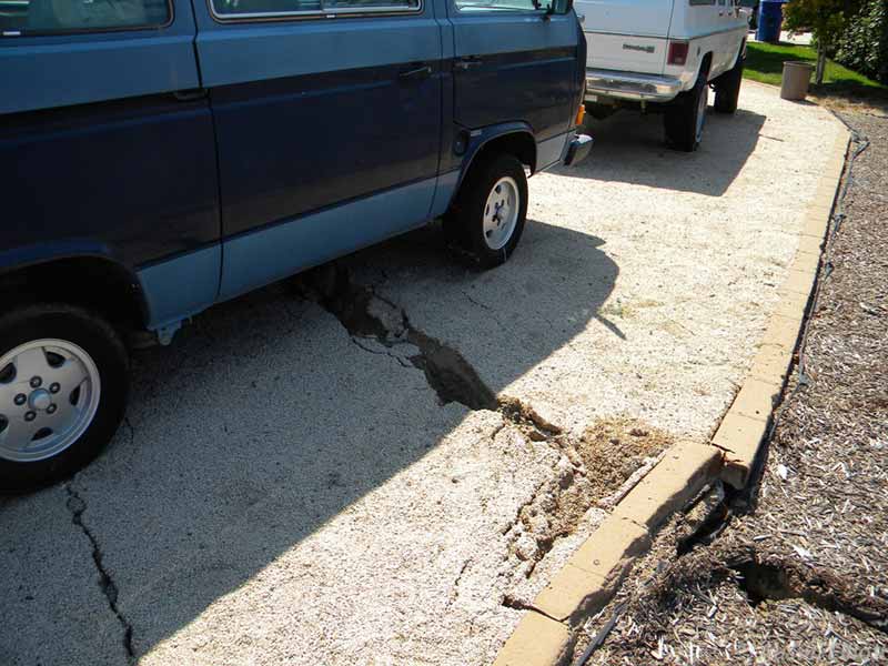
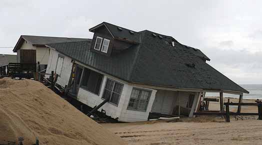
Many other faults lack compelling evidence of recent activity but are known to have ruptured at the ground surface during an earlier geologic age (the past 600,000 years, for example). Those faults are considered to be of lesser hazard and are sometimes classified as “potentially active”. While such faults may be less likely to rupture, it does not mean they won’t during the life of a home. The 2014 Napa earthquake, for example, which resulted in a half-billion dollars in damage in the affected counties, was caused by movement on a potentially active fault – the West Napa Fault – that ruptured through streets, pipelines and homes in neighborhoods of the City of Napa (see picture above). (Fortunately, the potentially active traces of this fault had been previously mapped by the State Geologist and were included on a map in the Napa County General Plan Safety Element – so, they were disclosed in NHD reports issued before the earthquake by First American and JCP-LGS.)
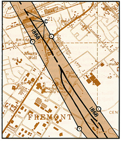
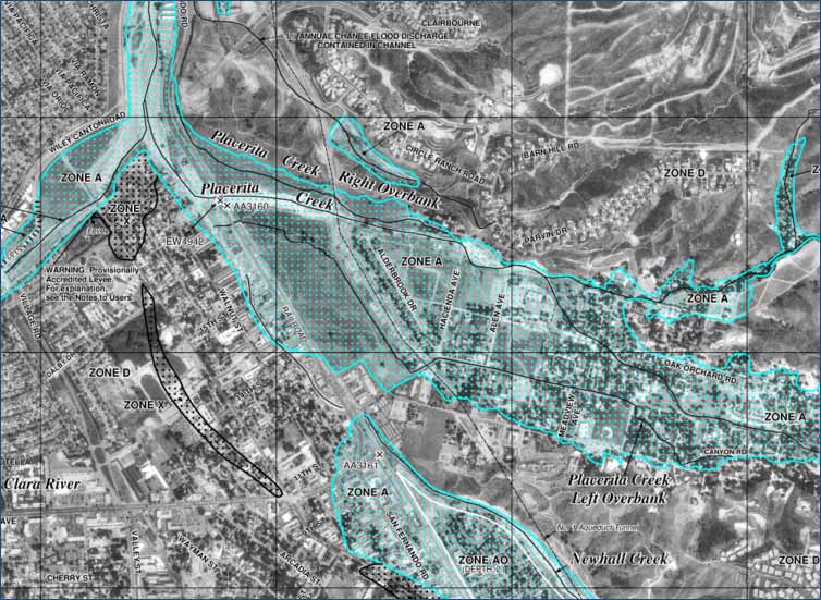
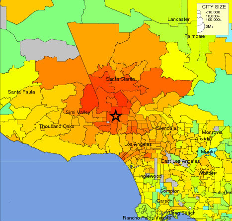
Alquist-Priolo Fault Zones: Surface fault rupture occurs when movement on a fault deep within the earth breaks through the surface causing ground displacement. This ground rupture occurs along fault lines, and is normally limited to a fairly narrow zone along the path of the primary fault, and to a lesser degree along secondary faults. In 1972 the State of California passed a law to identify active faults and regulate development where they might rupture at the ground surface. Pursuant to this Alquist-Priolo Earthquake Fault Zoning Act the State Geologist has issued a series of regulatory fault maps. Those official maps (see example at right) designate a zone about a quarter-mile wide centered on the active fault trace (called an “Alquist-Priolo zone”). These state-level fault zones affect real estate in two principal ways.
First, they are zones of “required investigation” for a development of four or more units intended for human occupancy (cities and counties regulate local development, however, and may be more restrictive). The state requires the developer to hire a California-licensed Professional Geologist or other appropriately licensed professional to investigate the ground beneath the site to ensure that no structure for human occupancy is built across an active fault trace. Second, in property transfers, with few exceptions, the transferor (typically the seller) must disclose to the prospective transferee (typically the buyer) the fact that any portion of the property is within an Alquist-Priolo zone. This notifies the buyer that regulatory constraints may be imposed on how the new owner may later develop the parcel. The statutory Natural Hazard Disclosure Statement includes a space for making this disclosure.
(Note, however, that being in an Alquist-Priolo zone has little bearing on the intensity of ground shaking in an earthquake. Outside this zone shaking can be equally or more intense depending on the type of soil at the site and how that soil may amplify seismic waves.)
Landslides
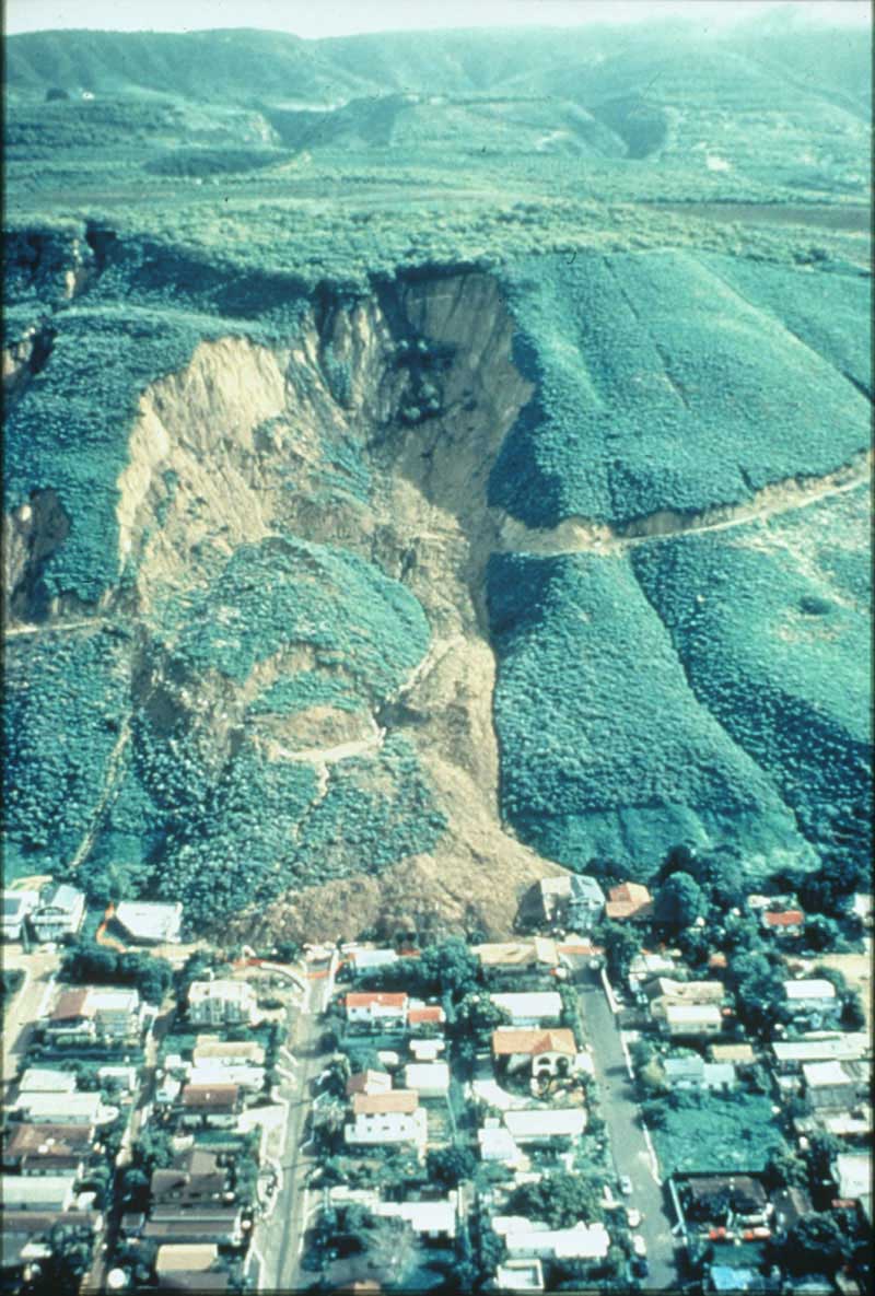
Landslides are a common hazard on sloping terrain. They can range from slow, downslope creeping of soil, to rapid and dangerous movements of unstable bedrock and water-saturated soil (debris flows) as may be triggered by torrential rainfall or earthquake shaking. New or existing landslides can also be influenced by construction activity (such as overloading or undercutting a slope), unusual wetting (such as excess irrigation onto, or natural spring discharge into, a slope), or erosion. The probability of landslide occurrence increases as slope increases.
The State of California has created a series of regulatory maps pursuant to the Seismic Hazard Mapping Act of 1990. These statutory maps designate zones where earthquake shaking might cause two types of ground failure: liquefaction (on flatlands) and earthquake-triggered landslides (on slopes). The seismic hazard maps affect real estate in two principal ways: by requiring a geologic site investigation before a property within a hazard zone is developed, and by requiring disclosure to a prospective buyer of the fact that any portion of a sale property is within this regulatory zone. The statutory Natural Hazard Disclosure Statement includes a space for making this disclosure.
The statutory seismic hazard maps are intended to show only where these hazards may result from seismic shaking – they should not be relied upon to show where landslides could be triggered by rainfall or other causes unrelated to earthquakes.
Finally, cities and counties may be more restrictive than the state in designating and regulating landslide hazard zones. The locally designated zones are typically mapped in the city or county General Plan Safety Element. Not only do these local zones often differ from the state zones, but city and county planners often identify additional and different types of natural hazard zones in order to best regulate land use within their jurisdiction. Most developments in areas with steep slopes require substantial earth movement and cut-and-fill activity, which require careful design to mitigate slope problems and may be strictly regulated by the local jurisdiction.
Liquefaction
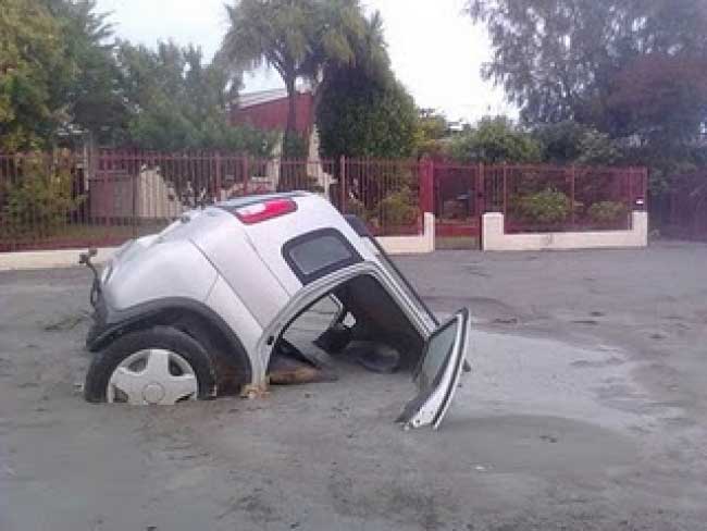
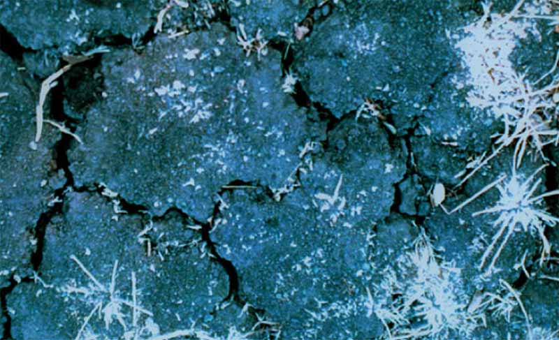
Liquefaction is an uncommon soil process by which loose, water-saturated sediment (typically sand or silt) just below the ground surface temporarily loses its strength during an earthquake and acts as a fluid. Structures built above on the ground surface can sink, tilt, and suffer significant structural damage in extreme cases. In the process the liquefied granular sediment can be ejected upward through soil cracks and onto the ground surface. Liquefaction is generally limited to flatland situations (such as floodplains) and is usually the result of strong to severe earthquake shaking.
The State of California has created a series of regulatory maps pursuant to the Seismic Hazard Mapping Act of 1990. These statutory maps designate zones where earthquake shaking might cause two types of ground failure: landslides (on slopes) and liquefaction. The seismic hazard maps affect real estate in two principal ways: by requiring a geologic site investigation before a property within a hazard zone is developed, and by requiring disclosure to a prospective buyer of the fact that any portion of a sale property is within an earthquake-triggered landslide or liquefaction zone. The statutory Natural Hazard Disclosure Statement includes a space for making this disclosure.
Finally, cities and counties may be more restrictive than the state in designating and regulating liquefaction zones. The locally designated zones are typically mapped in the city or county General Plan Safety Element. Not only do these local zones often differ from the state zones, but city and county planners often identify additional and different types of natural hazard zones in order to best regulate land use within their jurisdiction.
Wildfire
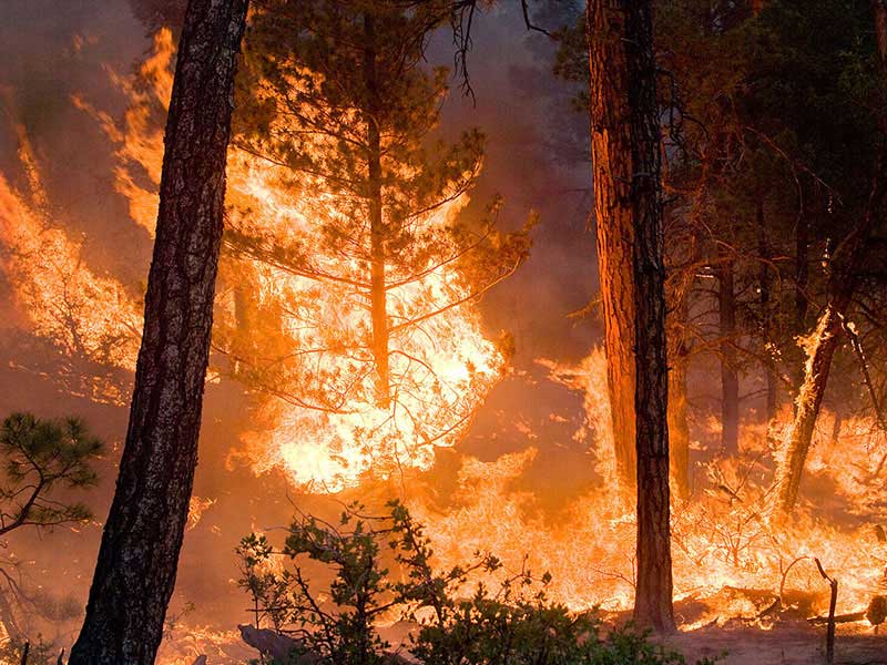
Conditions of terrain steepness, fuel loading and dry winds create a potential to spread a wildfire. Once ignited, fighting wildfires is made more difficult by an inadequate water supply, narrow roads, evacuation congestion, and other factors. In areas of wildfire potential, zones are typically designated that rank the fire threat level. Fire risk is generally greater for higher threat levels.
The California Department of Forestry and Fire Protection (CAL FIRE) designates fire hazard zones throughout the state. Those zones affect real estate in two principal ways. First, in the State Responsibility Area (SRA), where the state has financial responsibility for wildland fire response, the primary emergency responder is typically CAL FIRE. Because state fire stations are somewhat farther apart than are municipal fire stations, a first response to a structure fire may take longer.
Second, CAL FIRE designates Very High Fire Hazard Severity (VHFHS) zones in local responsibility areas (that is, areas served by municipal fire departments). Cities and counties may be more or less restrictive than the state in designating VHFHS zone boundaries within their jurisdiction. So, city and county VHFHS zones often differ from the state-designated zones.
In both the SRA and VHFHS zones, certain fire hazard mitigation measures are imposed by the applicable fire jurisdiction (through fire and building codes, for example) and those regulations may create additional costs for the property owner or limit how the land may be used. Such measures may include regular vegetation management, defensible space clearance, fire-safe landscaping, Class A roofing materials, chimney spark arresters, and certain building design and construction restrictions.
Largely for the above reasons, California law requires a seller to disclose to a prospective buyer the fact that any portion of a sale property is within an SRA or VHFHS zone. The statutory Natural Hazard Disclosure Statement includes a space for making this disclosure.
Of historical interest, in 2011 the State Board of Equalization imposed a new fire prevention fee on habitable structures located in the SRA. The yearly fee, initially set at $150 per structure, was increased in 2015 to $152.33 and paid for various activities to prevent and suppress fires in the SRA. In July 2017 Assembly Bill 398 suspended that fee until 2031. The fire prevention activities formerly paid for by the SRA fee will continue but, according to the legislation, will now be funded by a different source, rather than property owners in the SRA.
Dam Failure Inundation
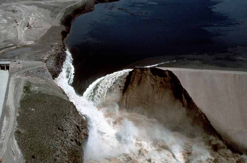
Dams and reservoirs can hold large volumes of water and represent a potential downstream flooding hazard due to failure or overtopping of the dam caused by extreme runoff events, landsliding, earthquake shaking and other events. In California, dam owners are generally required to map the downstream area that must be evacuated in the event of a dam failure. This potential inundation zone is a “worst-case scenario” that assumes instantaneous dam failure with the reservoir filled to capacity. However, dams rarely fail instantaneously, and reservoirs are not filled to capacity at all times. Dam failure inundation zones are not FEMA regulatory flood zones and a property’s location in a dam failure inundation zone does not itself trigger the FEMA flood insurance requirement.
California law requires disclosure to a prospective buyer of the fact that any portion of a sale property is within a mapped dam failure inundation zone (even during a drought when the reservoir is empty). The statutory Natural Hazard Disclosure Statement includes a space for making this disclosure.
Flooding
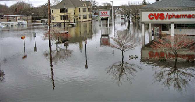
In 1968, the US Congress created the National Flood Insurance Program (NFIP). Now administered by the Federal Emergency Management Agency (FEMA), the intent of the NFIP is to reduce future flood damage and to provide protection for property owners from potential losses through the purchase of federal flood insurance. The NFIP provides affordable flood insurance for property owners by encouraging communities to adopt and enforce floodplain management regulations. These efforts help mitigate the effects of flooding on new and improved structures.
FEMA produces Flood Insurance Rate Maps (FIRMs) that show areas in a community that are subject to flooding. The maps depict common physical features in the community, along with information that allows the identification of Special Flood Hazard Areas (SFHA), the location of a specific property in relation to the SFHA, the base (or “100-year”) flood elevation or depth at a specific site, the magnitude of flood hazard in a specific area, regulatory floodways, flood insurance risk zones, and areas subject to inundation by the 500-year flood. A SFHA is any risk zone “A” or “V” on a FEMA flood map. (Source: FEMA website.)
In 1998, the California Legislature mandated the disclosure of SFHAs in real property transactions, along with certain other disclosures of flood, fire and seismic hazard zones. The seller's agent or the seller without an agent must disclose to the buyer if the property is in a SFHA. The statutory Natural Hazard Disclosure Statement includes a space for making this disclosure.
Tsunami

A tsunami (often misnamed a "tidal wave") is a series of ocean waves typically generated by a major undersea earthquake or landslide. Historically, in California, tsunamis have most often been caused by distant earthquakes along the Pacific Rim, such as in Japan, Russia, Alaska and Chile. For example, the catastrophic tsunami caused by the great 2011 Japan earthquake (magnitude 9), after destroying coastal cities along Japan’s Sendai coast, raced 5,000 miles across the Pacific Ocean and caused millions of dollars in damage to several California harbors. A potential nearby source of tsunamis is the Cascadia subduction zone, a great undersea earthquake fault off the coast of Washington and Oregon that extends southward along the northern California coast. Low-lying coastal communities are most at risk from tsunami inundation. Beyond the immediate coastal area, there is little or no tsunami risk.
Although potential tsunami inundation is not a required disclosure under California law, increasingly coastal municipalities regulate development to minimize the threat of tsunamis to life and property. For this reason, a prospective buyer is likely to consider it material to a transaction if the sale property is located in a tsunami zone that is designated by a city or county in its General Plan Safety Element.
Seiche
A seiche is a wave in a lake, reservoir, or bay that is caused by earthquake shaking. A large earthquake can generate low, rolling waves in the earth that are imperceptible to people. These waves, which may originate from an earthquake thousands of miles away, can cause the water body to “slosh” back and forth. In extreme cases, the oscillating water body can cause shoreline inundation. For example, the northern hemisphere’s largest recorded earthquake (Prince William Sound, Alaska, in 1964) produced seiching in lakes and bays over a thousand miles away and sunk fishing boats in a Louisiana harbor.
While California law does not require disclosure of seiche hazard zones, some shoreline municipalities along inland lakes and reservoirs have designated seiche runup zones in their General Plan Safety Element, which a prospective buyer may consider to be material to a property transaction.
Seismic Shaking
When movement occurs along a fault, most of the energy generated is released as ground vibrations (seismic waves), which we perceive as earthquake shaking. Ground shaking intensity at a site generally varies with the magnitude of the earthquake, the distance from the fault that ruptured, and the type of bedrock or soil at the property. (The direction in which the fault ruptures may also play a role.)
Most California communities are subject to some level of ground shaking hazard, which may vary from place to place within the community during any given earthquake. Other factors being equal, shaking will be more extreme on soft soils (such as water-saturated silt and clay along a bay margin or loose sandy deposits on a river floodplain) than on solid bedrock, and structures built to modern seismic codes will generally suffer less damage than older structures that have not been retrofitted for seismic safety.
Earthquake shaking causes over 90% of the damage in an earthquake, yet real estate disclosure of this paramount hazard is not required by state law. While California law requires the State Geologist to delineate regulatory earthquake fault zones and earthquake-triggered landslide and liquefaction zones for real estate disclosure, there is no legislative mandate to delineate earthquake shaking zones for this purpose. However, a growing number of municipal governments have adopted ground shaking maps in their General Plan Safety Element and often consider that hazard when evaluating design and construction plans in a building permit application. Where a Safety Element map shows intense earthquake shaking is expected on a property, a prospective buyer may consider that fact to be material to the purchase decision.
Expansive Soil
Certain clay minerals if present in a soil can cause it to expand when wet and shrink upon drying, a phenomena known as shrink-swell potential. Such “expansive soils” can pose a hazard to structures founded upon them if not appropriately engineered. The effects of expansive soils are most evident in areas of moderate to high precipitation, where prolonged drought is followed by prolonged periods of rainfall. Recent estimates put the damage from expansive soils as high as $7 billion annually across the U.S. (source: FEMA). However, because this hazard develops gradually it is seldom a life-safety threat.
This condition can be aggravated by the way a property is maintained or irrigated. Excess irrigation of landscaping, for example, or removal of significant amounts of native vegetation could create or worsen this condition. Where shrink-swell potential is known to be significant, certain engineering and construction standards may be required for new buildings and remodeling, which could affect project cost or approval. California law does not mandate disclosure of expansive soils zones; however, many cities and counties include such a map in their General Plan Safety Element, and a prospective buyer may consider this to be material if the sale property is located in the locally mapped zone.
Subsidence and Settlement
Ground subsidence is the settling or sinking of the ground surface with little or no horizontal movement. This condition is usually gradual and associated with the extraction of natural gas, oil, or water from below ground, or with organic decomposition of buried peat deposits and a resultant loss in soil volume. Although differential settlement generally occurs slowly enough that its effects are not dangerous to building inhabitants, over time it can cause significant damage to building foundations, pavements, aqueducts and pipelines.
Settlement can also happen suddenly as a result of earthquake shaking. For example, many of California’s urban areas are protected from flooding by earthen levees, and those levees are subject to settlement in an earthquake if not properly maintained. This could pose a risk of overtopping and failure of these critical flood-protection systems during a major earthquake.
In addition, in California’s non-urban areas, levees keep the state’s clean drinking water from being contaminated by salt water intrusion from the San Francisco Bay. Over half of that levee system is vulnerable to failure due to earthquake-triggered settlement. (Source: California Department of Water Resources, 2011)
Sea Level Rise
According to the Intergovernmental Panel on Climate Change 5th Assessment Report, released in September 2013, global average sea level is projected to rise by 10-39 inches by the year 2100 (relative to mean sea level from 1985 to 2005), depending on the atmospheric carbon emissions scenario assumed. This projection is considered to be based on the best available science in the “Sea Level Rise Policy Guidance” document adopted by the California Coastal Commission in August 2015. These projections are likely to change over time as climate science progresses.
Perhaps the most obvious and widespread consequence of sea level rise is inundation and flooding of land. Sea level rise will not only cause permanent land inundation near coastlines, it will increase and expand the 100-year floodplain in coastal communities. Thus, the number of residents at risk during storm events would increase. Shorefront land composed of fill is at risk for inundation because of low elevation and subsidence over time due to compaction from buildings and soil desiccation. Additionally, shoreline dikes and sea walls likewise may be at risk for overtopping and inundation. The National Oceanographic and Atmospheric Administration (NOAA) provides an online mapping tool that illustrates the scale of potential flooding along the coterminous U.S. coast assuming various sea-level rise scenarios (visit: https://coast.noaa.gov/slr/ ).
California law does not currently mandate disclosure of sea level rise in real estate transactions. However, in 2015 the state began updating its General Plan Guidelines for cities and counties to include land-use planning to avoid sea level rise hazards within their municipal jurisdictions. In addition, many coastal cities and counties are independently addressing global sea level rise by adopting land-use policies that anticipate rising sea level.
Increasingly, these local policies result in sea-level rise inundation zones on maps in the municipality’s General Plan Safety Element, and those zones guide building departments in the permit approval process. Hence, a prospective buyer may consider it to be material if the sale property is located in such a locally designated hazard zone. (Source: NOAA, California Coastal Commission, California Governor’s Office of Planning & Research)
Coastal Erosion
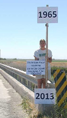
The California coast, while a world-famous scenic resource, is potentially vulnerable to coastal bluff retreat, bluff-top erosion, gullying, and beach erosion, all of which are generally considered geologic hazards. Coastal bluffs can be subject to rapid landscape change through undercutting and slope collapse, erosion and cliff retreat. Coastal erosion occurs as a result of natural processes such as tides and currents, long-shore drift, storm surge, sea level rise, and earthquakes. Erosion rates depend on the underlying geologic materials and their susceptibility to the weathering effects of gravity, wind, and water (including rain and waves).
Coastal erosion is not among the natural hazards required for real estate disclosure by the State of California. However, local officials may consider it to be a factor in deciding a building permit application for coastal parcels and may require appropriate steps to mitigate this hazard, which could affect project cost, permit approval and, ultimately, land use. Many cities and counties along the California coast include a map of coastal bluff or erosion hazards in their General Plan Safety Element, and a prospective buyer may consider this to be material if the sale property is located in the locally mapped zone.
Guide to Residential Property Environmental Hazards
What Are Hazardous Substances?
Chemicals in our environment are a controversial subject. This is because their effects on human health are often not well understood. Both the government and the public want clear standards that define when a substance is considered “hazardous.” Unfortunately, it is not always easy to determine such a clear standard. Precise instruments allow us to detect a wide variety of substances even in very small concentrations. Sometimes these substances are only detectable in the parts per billion (ppb) or parts per trillion (ppt) ranges. In these cases, the concentrations are at or near the limit of our ability to even detect them.
If scientific study shows that a particular chemical is known or suspected to adversely affect our health, that substance could become listed as an official hazardous substance. The list of what “is” and “is not” a hazardous substance changes. With increased research, substances are added and, in some cases, removed.
The potential health implications make us question the presence of chemicals in our environment. It’s important to understand that any risk associated with a substance is dependent on both the concentration of the chemical and the length of exposure time. Some scientists believe that a “threshold” level exists for many chemical concentrations below which there are no known or anticipated adverse health effects. This allows standard concentration limits of some chemicals to be established. These standards are called “Maximum Contaminant Levels” (MCL), and they are enforceable by the Environmental Protection Agency. If these levels are exceeded, the substance must be cleaned up until it is at or below the MCL.
The term “hazardous substance” is used in this report as synonymous with “hazardous waste” and “toxic substance.” In general, the terms refer to a material with potentially harmful affects. Once a particular substance is determined to be harmful, it may become regulated by one or more environmental laws. When this happens, it is termed “listed.” Once a chemical is “listed,” sites that have spilled or leaked the substance may be required to clean it up.
Hazardous Substances in Perspective
As is true with any hazardous substance, the mere presence of it is not a threat to human health. In order to pose a health risk, that substance must come into physical contact with the body by eating, drinking, inhalation, or skin contact. It is the likelihood of physical exposure to a substance that must be carefully examined to determine an acceptable level of risk. Information on how contaminated sites can or cannot affect the property is vital in making decisions. Inaccurate perceptions could lead to making misinformed decisions. Two lines of logic to consider when analyzing risk are:
- We make daily decisions based on familiar and acceptable levels of risk because we feel the benefits outweigh the potential consequences. For instance, although we know driving freeways might be dangerous, we drive them anyway because convenience and speed makes this risk acceptable. Many risks we undertake everyday aren’t considered hazardous simply because they are familiar.
- Everyday, we make decisions based on what is most important to accomplish first, second, etc. This is necessary because if all problems were assigned equal importance, nothing could be accomplished. Risk is commonly considered similarly or, in other words, as “relative risk.” This consideration is based on deciding what “risk” has the worst or immediate adverse consequence and then address that risk first.
Often, decisions are not based on scientific analysis and hard data, but on perceived risk and public opinion. In the environmental arena, these two approaches go head to head. Public attention may be focused on certain environmental hazards based on a dramatic and well-publicized environmental problem. Unfortunately, this may lead to a diminished concern for other environmental issues that may pose more immediate concern. This line of thinking is not directed at undermining the significance of large-scale contamination, but is meant to direct attention to the “big picture.”
Many studies indicate that things we do on a daily basis in our homes may expose us to a greater overall health risk than living next door to virtually any contaminated site. It’s hard to imagine that many of the items we take for granted in our homes have higher concentrations of hazardous substances and expose us for greater amounts of time than just about anything we encounter in normal outdoor activities. This is where familiarity with items such as “drycleaned” clothes, many air fresheners, mothballs, paints or shoe polishes make the hazardous substances in such things acceptable. In certain cases, chemicals that are strictly regulated in industry are not regulated in homes. An example is methylene chloride, which the EPA found in about one-third of 1000 common household products in a 1987 study. Methylene chloride is regulated in factory emissions, but not within homes.
Understanding a variety of issues is important for making informed decisions. Evaluating risks accurately in order to avoid over— or under—reacting is a task best completed based on sound, accurate information.
Groundwater
The water in lakes, rivers, and groundwater all together only account for about 0.6% of the total water on Earth. Of these, groundwater is the most important fresh water supply. About half of the United States depends on groundwater for their drinking water. An expanding population and economy has prompted a dramatic increase in the demand for water from groundwater supplies. Many thought such water was immune from contamination. However, as more incidents of groundwater pollution occur, public interest in protecting our groundwater has increased as well as legislative protection of this resource.
Although the technical aspects of groundwater and groundwater pollution are beyond the scope of this report, the basic concepts are easy to understand and can help in evaluating other information in this report.
How Groundwater Reservoirs Form
In order to understand the basic principles of groundwater, it is necessary to appreciate the “hydrologic cycle.” This is the system by which nature circulates water. In short, water evaporates from the ocean and rises to form clouds. Water in the air condenses and eventually falls back to the earth in the form of rain, snow, sleet, hail etc. which then eventually flows back to the ocean.
We depend on precipitation that falls on land to replenish our fresh water supply. Precipitation can fall directly into water bodies, from run-off, or soak into the soil. Much is absorbed by plants or evaporates, but a portion seeps down into the groundwater. Technically, “groundwater” is water located in water-saturated zones below the surface. Water located in unsaturated zones is simply called “soil water.”
Groundwater is primarily stored in “aquifers.” Usually, aquifers consist of gravel, sand, clay or fractured rock. Groundwater is stored in the pores and cavities of sediments or in rock fractures. It does not occur as an underground “ocean” or “river” except perhaps in a rare cave-type environment. Aquifers may consist of one continuous “layer” or as several layers stacked-up like pancakes.
How Groundwater Moves
Groundwater is added to (recharged) by water seeping down through the ground and is released (discharged) when it intersects a surface body of water such as a lake or stream or when it is pumped out. The surface area below the ground where the soil or rock is water saturated is called the “water table.” The water table is not fixed. It can move up and down as water is removed from or added to the aquifer.
In general, groundwater moves slowly. This is an important concept when considering groundwater contamination. The water can move as slowly as a few inches per year in clays. However, if the aquifer consists of loose sand and gravel, the groundwater can move hundreds of feet per year. Like water at the surface, groundwater moves with the gradient (i.e. downhill). However, groundwater can also move as a result of being under pressure. Pressurized water will move from high to low pressure areas. This works under the same principle as any material under pressure, such as fluid in an aerosol can.
Formation of Plumes
The Transport of Chemicals into Groundwater
Chemicals that are spilled or released into soil may dissolve in any water that is present. In some cases, the chemicals may be transported into groundwater by water slowly seeping downward. How fast this occurs and the details are complex, but water generally moves downward. Lateral movement is generally not significant until water reaches the water table. The contaminant concentration reaching groundwater is less than the concentration at the source because of dilution and breakdown that occur along the way.
As contaminants are slowly transported downward, they can chemically interact with other things in the water or soil. This can temporarily or permanently remove the contamination. Natural defense mechanisms such as biological degradation also act to naturally mitigate contamination to varying extents by removing or altering the contaminants. For instance, some bacteria that live naturally in soil and groundwater can metabolize many of the contaminants in gasoline.
Contaminants become “pollution” if they reach concentrations high enough to be judged harmful to humans or the environment. Groundwater standards are set by the United States Environmental Protection Agency (EPA) and state agencies. Contamination can originate from a “point source” such as a leaking underground tank, or from a “nonpoint” source such as infiltration from agriculture (i.e. pesticides and fertilizers) or urban run-off (i.e. road salt or trace metals left on roads from tires and car emissions).
When contaminants enter the groundwater, they are slowly dispersed to form a diluted cloud or “plume.” Chemical reactions and biological breakdown can continue. Pumping, complex flow patterns, chemical and biological processes all affect the travel, size and shape of plumes. Some contaminants may be removed by a process called “adsorption.” Adsorption is the process by which a chemical adheres to grains in the soil. Although this does not remove the contaminant, it may immobilize it and help prevent it from spreading.
The size and extent of plumes are determined using “monitoring wells.” Such wells also help track clean-up efforts. Information from monitoring wells and other sources are used to determine appropriate mitigation recommendations. Clean-up methods can vary widely depending on local site conditions.
Leaking Underground Fuel Tanks
The most common type of contamination comes from leaking underground fuel tanks and piping systems. Underground tanks are common throughout California as well as throughout the United States. These tanks are predominantly used for storing fuel, although solvents used in high technology industries and other substances are stored in this manner also.
Why underground tanks? Many years ago, jurisdictions developed regulations with regards to fuel tanks for the “esthetic” protection of growing cities as well as providing important fire safety measures. For these reasons, the majority of fuel tanks must be buried. Unfortunately, the state building codes that regulate underground fuel tank construction did not keep up with changing technology. The result was that industry used traditional methods in building underground tanks and pipes. Today, there are laws in place that ensure strict building codes are followed in new tank construction, as well as upgrades for all substandard underground tanks.
When an underground tank leaks, the soil and/or groundwater can become contaminated. How much fuel actually gets into the soil depends on how big the leak is and how long the leak continues. Experience shows that leaking fuel “seeps” into the ground at a generally slow rate and usually does not travel very far. “Seeping” fuel into the soil can be likened to wetting the corner of a sponge. With only a small amount of water, only the corner gets wet and the rest of the sponge remains dry.
If a leaking underground fuel tank is discovered, the tank owner or responsible party must notify the appropriate Regional Water Quality Control Board (RWQCB) or county-level agency and submit an “unauthorized release form”. The responsible party must also make every effort to stop the leak and empty the tank if necessary. The RWQCB or county-level agency will then undertake the lead in clean-up efforts, with the tank owner or responsible party reporting directly to them. Until investigation and cleanup are complete, the tank owner or responsible party must submit reports detailing cleanup efforts to the lead agency at least every three months. If the investigation fails to confirm that a leak has actually occurred, no further corrective action will be required. For those Sites that do require corrective action, the cleanup process could take a few months to many years, depending on the severity of the leak. Additional information may be available through the Public Safety Officer or Hazardous Materials Specialist in the city who is often within the Fire Department or Public Works Department.
What is a “Superfund” Site?
“Superfund” is a common term for the “Comprehensive Environmental Response, Compensation, and Liability Act” (the "Act"), which was a law enacted by Congress on December 11, 1980, and is enforced by the U.S. Environmental Protection Agency (EPA). This legislation provides funding for clean up at the worst hazardous waste Sites in the United States. Because the moneys involved in clean up are large, this federal statute was dubbed “Superfund.”
The purpose of Superfund is to clean up or mitigate hazardous materials that pose an immediate and substantial danger to the public or the environment. This could be a chemical “spill” that requires immediate response or a site that requires long-term clean-up action. The chemicals found at Superfund Sites can vary but some have included familiar contaminants such as arsenic, lead and mercury. Other lesser known contaminants include toluene, pentachlorophenol and vinyl chloride. This Act also holds polluters liable for clean-up expenses as well as forces responsible parties to take clean-up actions.
How does a site get on the Superfund list? Proposed Sites are brought to the EPA’s attention in several ways. It could come from notification by the owner, complaints by citizens, identification by a state or local jurisdiction, or by special EPA investigations. A site is then placed on the Superfund, or “National Priorities List” (NPL) once the EPA determines that it represents a long-term threat to public health or the environment. The EPA makes this determination by evaluating such things as the likelihood that a site has released or has the potential to release hazardous substances into the environment, the characteristics of the waste (e.g. toxicity and waste quantity), and the number of people affected by the release. The government believes that “Superfund” funding is warranted if the site poses a significant and immediate health concern. Even if federal funding is not provided, the site may require action under other statutes.
Drinking Water: Tap vs. Private Well
Being in proximity to a contaminated site occasionally raises concern regarding the quality of the drinking water and whether or not the contamination is present in that water. One important question to keep in mind is “where does the drinking water come from… a municipal water system or a private well?” The answer to this question will help to resolve the issue of contamination.
In general, homes in urban areas are typically hooked up to a municipal water system. The water from this type of system is commonly referred to as “tap water”. Municipal water suppliers are required to meet stringent drinking water standards set forth by the US EPA. These drinking water suppliers provide reports, sometimes called consumer confidence reports, which outline where the water comes from and what substances are in it. The municipal water supplier should be able to provide these reports upon request.
On the other hand, if a home is not hooked up to a municipal water source but instead is using a private well on the property, then the US EPA regulations do not apply. The homeowner is responsible for the quality and safety of the drinking water. Keep in mind that being in proximity to a contaminated site does not necessarily mean the well will be contaminated. There is always the possibility that the contamination could be traveling in the opposite direction to where the private well is located, in which case the well water would remain uncontaminated. Another possibility is that the contamination could be at a much shallower depth than where the private well is drawing water. If the private well is deep, then it possibly can bypass contamination at more shallow depths. In any case, the US EPA recommends that well owners have their water tested annually.
Natural Gas and Hazardous Liquid Transmission Pipelines
Proximity to a transmission pipeline does not of itself indicate a safety risk. However, on September 9, 2010, a Pacific Gas and Electric (PG&E) natural gas transmission pipeline exploded in San Bruno, California, causing loss of life and extensive property damage. Following this incident much attention has focused on the presence of natural gas and hazardous liquid pipelines in the vicinity of residential neighborhoods. As a result, PG&E periodically notifies residents and businesses within 2,000 feet of PG&E's natural gas transmission pipelines about their proximity, and other gas utilities in California have done likewise. Therefore, many believe that notification of a transmission pipeline within 2,000 feet may be material to a residential property transaction.
Transmission vs. Distribution Pipelines
The 2,000-foot proximity determination in this residential disclosure report covers gas "transmission" and hazardous liquid pipelines only. It is important to note that every home that uses natural gas is connected to a gas "distribution" pipeline. Distribution pipelines are generally of smaller size and lower pressure than transmission pipelines. This disclosure does not include distribution pipelines nor is it meant to indicate there is no risk associated with distribution lines. While proximity to a pipeline does not of itself indicate a safety risk, excavation near a pipeline poses a definite hazard. For this reason, this disclosure includes an advisory about how to spot and avoid buried pipelines on and near a property.
The U.S. Department of Transportation, Pipeline and Hazardous Materials Safety Administration (PHMSA) administers the national regulatory program to monitor the transportation of natural gas, liquefied natural gas (LNG), and hazardous liquids by pipeline. PHMSA and the U.S. Office of Pipeline Safety (OPS) maintain a database of pipeline information called the National Pipeline Mapping System (NPMS) in cooperation with other federal and state governmental agencies and the pipeline industry. The NPMS is created using data compiled from mandatory submissions to PHMSA made by operators of pipelines and LNG plants, and from voluntary submissions made by breakout tank operators. The data is processed by private contractors. Since 2002, transmission pipeline and LNG plant facility operators are required to update their submissions annually.
The PHMSA website provides a Public Map Viewer that allows the general public to view pipeline maps in one county at a time. The viewer displays maps and associated data identifying transmission pipelines, LNG plants, and breakout tanks stored in the NPMS database. The data include information about the pipeline commodity (e.g., natural gas or liquid fuel), pipeline operator, agency contact, etc. The Public Map Viewer can be accessed at the following address:
https://www.npms.phmsa.dot.gov/PublicViewer/The pipeline disclosure in this report is based on a proximity search of the gas transmission pipelines and hazardous liquid pipelines depicted in NPMS Public Map Viewer at a scale of approximately 1:24,000. That map scale is the maximum resolution at which pipelines are displayed. At that map scale one inch on the map equals approximately 2,000 feet on the ground, which is the same scale as regulatory maps required for statutory natural hazard disclosure in California. NPMS data should be considered no more accurate than +/- 500 feet and must never be used as a substitute for contacting the appropriate one-call center prior to digging. To identify a specific pipeline owner/operator, please use the NPMS Public Map Viewer at the web address above. For policy and technical questions regarding NPMS, please contact PHMSA directly.
PRIVACY NOTICE
This website uses cookies and similar technologies to manage your sessions, manage content, and improve your website experience. To learn more about these technologies, your options, and about other categories of personal information we collect through this website and how we may use it, please see our Privacy Policy.